Rim to Rim October 2021
My apologies in advance—this is going to be a bit long. Trying to condense a two-day trip of a lifetime into just a few paragraphs is no easy task! Grand Canyon Rim to Rim is no easy feat.
My love for the Grand Canyon knows no bounds. It’s my favorite of all the National Parks and, while it feels like it’s practically in my backyard, it still sits six hours away. We try to make the trip at least once or twice a year, and over the years, we’ve done some limited hiking along the South Rim, as well as the South Kaibab and Bright Angel trails.

Down the North Kaibab
One evening in the spring of 2021, we were at a friend’s house when she told us about her upcoming Grand Canyon Rim-to-Rim hike in October. She didn’t want to hike it alone and was looking for a hiking partner.
Never in a million years did I think I would consider a hike of this magnitude. I loved hiking in the mountains and deserts of Arizona, but my typical hikes covered only 3–5 miles round trip.
By the end of the evening, she had talked me into joining her. I left feeling excited, scared, uncertain, and anxious—all at the same time. But, I had only about six months to prepare.
I trained whenever my schedule allowed and watched countless YouTube videos from people who had completed the hike. I studied the trail, listened to their advice, and tried to prepare myself for what lay ahead.
Let me just say: nothing can truly prepare you for a Rim-to-Rim hike.

Breathtaking Canyon Views
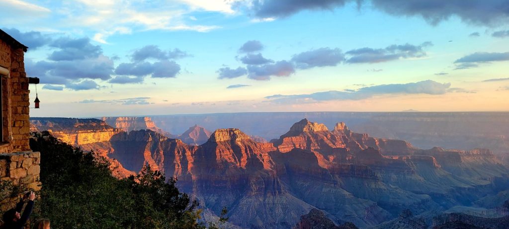
The views are breathtaking, and the sunsets are spectacular. The canyon’s mood shifts from hour to hour, even minute to minute, as the changing light paints the landscape in new ways. Then daylight slips away, and the night shift takes over. As an International Dark Sky Park, the Grand Canyon rewards you with a dazzling blanket of stars stretching across the canyon sky.
Our route takes us from the North Rim to the South Rim, following the North Kaibab Trail for 14½ miles, crossing the Colorado River, and then climbing 6 miles up the South Kaibab Trail.


Grand Canyon Lodge Cabins
We arrived at the North Rim a couple of days before the hike to give ourselves time to acclimate to the 8,500-foot elevation. We rented a cozy little cabin and spent the next couple of days hiking around the North Rim. The night before our big adventure, we enjoyed a campfire-cooked spaghetti dinner right at the edge of the canyon—a little carb-loading to fuel us for the hike ahead.
Sadly, several of these cabins, along with the Grand Canyon Lodge, burned in the Dragon Bravo Fire on July 12–13, 2025.
On the third morning, our alarms went off at 3:30 a.m. as we prepared for our 4:30 departure. The North Rim greeted us with a chilly 35 degrees, so layering up with Under Armour was a necessity. We knew we’d warm up quickly once we started hiking, but at that hour, we were grateful for every layer.

The Hike – Day 1
Day 1 Destination: The Colorado River
We arrived at the North Rim trailhead ahead of schedule, around 4:15, said goodbye to our hubbies, and started the journey.
The first thing you can’t help but notice on this trail is the overabundance of mule shit and pools of urine scattered everywhere. In some spots, the stench hits you so hard you just want to vomit. The good news? We only had to endure it until we reached the tunnel, which marks the turnaround point for the mules. The bad news? The tunnel sits 1.7 miles down the trail.
We had about two hours of hiking in the dark ahead of us. You might think 14½ miles downhill would make for an easy hike, but it’s far from a stroll in the park. Almost immediately, we tackled a series of switchbacks packed with steps—some short, some tall, and some VERY tall. My short legs did not appreciate those tall ones one bit.
Apparently, giants built this trail.

Manzanita Rest Stop
The steps seem endless, and every one takes a toll on my legs and back. My backpack feels heavier with every passing minute, slowing my pace, and I thank God for my hiking poles. We have 6,300 feet to descend before reaching the river, and I start to wonder just how long this day will feel before we finally get there. The South Rim is still so far away.
We reach the Manzanita Rest Area 5.5 miles in, and I welcome the much-needed break. We shed our Under Armour layers, grab a snack, and refill our water supplies. The deeper we descend into the canyon, the hotter it gets, with temperatures expected to climb into the 90s by mid-afternoon.

Cottonwood Campground Rest Stop
Our next water stop was Cottonwood Campground, 6.8 miles into the hike and about halfway to the river. We grabbed another snack, filled our CamelBaks, and I drenched myself in water before continuing on.
My hiking partner took pity on me and offered to switch packs for a while, giving my aching back a much-needed break. She only carried a fanny pack, but my back greatly appreciated the reprieve. She was just one of the many angels who helped keep me going on this hike.

On to Phantom Ranch
We reached the bottom of the Canyon after crisscrossing Bright Angel Creek seven times when a thunderstorm started moving in overhead. I felt a little nervous that the storm might turn intense, but it turned out to be nothing more than a nice passing rain shower that cooled us down.
The bottom of the Canyon is stunningly beautiful. The trail weaves in and out of side canyons, bringing you up close and personal with rocks that date back 1.8 billion years. We finally arrived at Phantom Ranch around 6:30 p.m.
My goal was to cross the Colorado River while it was still light so I could capture some good GoPro footage, but it wasn’t meant to be. We still had about a mile to go before reaching the river, and darkness had already settled in. So we pulled up a bench in the amphitheater, kicked back, and rested for a few hours.
Of course, we had to try the obligatory Phantom Ranch lemonade. Honestly, I don’t see what all the hype is about—I’ve had better lemonade! After our little refreshment, we tried to catch a few hours of sleep.
The next challenge awaited us: a long, steep climb up the South Kaibab Trail—7½ miles from Phantom Ranch with a grueling 4,700-foot elevation gain.


Day 2: Up the South Kaibab to the South Rim
Day 2 destination: the South Rim. Around midnight, we packed up and headed out. The South Kaibab Trail has no water, so we filled our CamelBaks and spare water bottles and stocked up as much as we could. All that water added plenty of weight, and with my legs and back already sore, every step felt slower.
We crossed the Colorado River in the darkness, walking over a bridge that seemed to stretch on forever. Then we started the dreaded ascent.
Up ahead, we could see a few trail runners heading down the trail, their headlamps glowing like lightning bugs in the darkness. Meanwhile, we faced mile after mile of climbing.
I can describe the South Kaibab Trail in three words: steep, switchbacks, and stairs.
At one point, I seriously asked my hiking partner how much a helicopter ride to the top would cost. Yes, I had my credit card with me! She kindly encouraged me to keep going instead. LOL. One of the many times during this adventure when a little encouragement kept me moving forward.


The Tipoff
I needed frequent rest stops, which slowed our progress even more. Three miles up, we finally reached our first rest stop, the Tip-Off. It was still dark, but we welcomed the chance to sit down, catch our breath, and take a load off for a few minutes.
The most grueling part of the trail still lay ahead: 1½ miles of seemingly endless switchbacks and stairs climbing the canyon wall. Up and up we climbed, one step at a time.
At the 4½-mile mark, we finally reached Skeleton Point. Hallelujah! We had conquered the last of the switchbacks and stairs, at least for a while. The south rim was getting closer. My water supply held out well, but I felt tired, sore, and hot. As I sat there catching my breath, I couldn’t help thinking, I know why they call it Skeleton Point. I felt like I could curl up and die right there.
It was time for a snack and a good rest. Only three more miles to the top. I can do this.
What we didn’t know at the time was that our hubbies stood at the top of the canyon at Yaki Point, watching us climb the trail and cheering us on. They yelled down into the canyon, but the distance swallowed their voices. We never heard them.

Onward and Upward
Six miles into the hike, we reach Cedar Ridge, and the trail is getting crowded. With only 1½ miles to the top, many hikers use Cedar Ridge as their turnaround point for a day hike. There are bathrooms here, but no water.
One thing that really annoyed me about the bathroom stops: every bathroom sits up on a hill. So, just when you think you’ve finally found a place to rest, you have to climb up some more just to use the bathroom. Talk about adding insult to injury!


Ooh-Aah
A half-mile later, we arrived at Ooh Aah Point (yes, it’s really called that!). We stopped for a moment to catch our breath and take in the scenery. By now, the trail had become really crowded.
One mile to go—and we still had to tackle the final 11 switchbacks before reaching the top. When we rounded the corner and finally saw them, tears of joy literally filled my eyes. We were almost there!
This time, we could hear our hubbies calling out to us. When we yelled back to let them know we could see and hear them, they started down the trail to meet us. My friend’s husband grabbed my pack and carried it the rest of the way up. I will be eternally grateful for that gift of strength when I had so little left. 💓
Although this picture doesn’t show all of the switchbacks, it gives you a good idea of what lay ahead. With 19 miles of trail already behind us, those final 11 switchbacks actually weren’t so bad. The steps were nice and short, making the climb much easier. And with my husband at my side, I found the wings I needed for that final push to the top.
Day 2, 12:30 p.m. 32 hours, 24 1/2 miles, over 87,000 steps according to my FitBit.

We Made It!
Many thanks and heartfelt gratitude go to my hiking partner for her incredible support and patience along the way. I could not have done it without her constant encouragement. I’m pretty sure she could have completed this hike in a single day—I’m convinced she’s part mountain goat!
Thank you to the angels who sat on my shoulder and watched over me throughout this journey. I’m sure Jess was one of them.
Last, but definitely not least, thank you to my hubby for his unwavering support and love. I’m sure his worry and stress levels were off the charts during those two days! Knowing he was waiting for me at the top gave me the strength and determination to tackle every step and switchback until I finally made it.
Would I do it again? Knowing what I know now, I’m actually thinking about it. We’ll see…2028???
Thanks for stopping by!
Until next time – Much love,
Romin, Pete, & Lori

Note: all links in this newsletter are secure and will take you to our photo albums, videos, or to a secure website. Click on any photo to enlarge it.
QUICK LINKS
Video: Hike Grand Canyon Rim to Rim
Photo Album
Return to Home Page
To read more about our adventures, browse links to our past newsletters here. You can also subscribe using the form below to receive a notice whenever we post a new newsletter. We will never sell your email address. You will only receive a notice when a new newsletter is posted.